Edgewater Towers Opposition to “Jack in Box” Project
PLEASE SEND ALL COMMENTS Los Angeles City Planning by 7/6/20
c/o Nick Vasuthasawat – nick.vasuthasawat@lacity.org
City of Los Angeles Department of City Planning 200 N. Spring Street, Room 720 Los Angeles, CA 90012
Attention: Nick Vasuthasawat, City Planning Assistant
Re: Case No. : CPC-2018-504-DB-DRB-SPP-CDP-MEL CEQA No. : ENV-2018-505-17346
Location : 17346 West Sunset Boulevard Dear Mr. Vasuthasawat:
I represent the Edgewater Towers Condominium Homeowners Assoc. (Edgewater). The Edgewater property is located immediately adjacent to the proposed 17346 Sunset Boulevard Project (the “Project”), just uphill, approximately to the southeast.
Edgewater opposes the Project. Edgewater also objects to the Public Hearing scheduled for 7/6/20, the Monday following the 4th of July holiday when many nearby residents may be out of town. The date of the hearing and its 12:30 p.m. start time seems calculated to diminish public input regarding the Project.
Further, the Project has been in the process of being re-designed and it is unclear if the final version of the Project has been provided. In 6/16/20, the Project Applicant’s attorney contacted Edgewater and requested permission to allow a surveyor to enter Edgewater’s property to create an elevation showing the height of the proposed Project structure relative to Edgewater’s pool deck and lower floor levels. Applicant’s attorney indicated that this was requested by L.A. City Planning.
Edgewater agreed to provide permission to conduct the survey on its property. On 6/23/20, a new survey of the Project was conducted by the Applicant and the results of this survey are not yet available. Neighborhood residents and associations are therefore unable to review the new plans and then meet to determine their positions before the Public Hearing is held.
Rushing this Project to a premature hearing during the present pandemic also impairs the ability of the public to fully vet the Project and provide input to the City.
INTRODUCTION
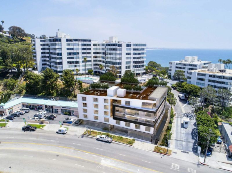
The Project is on a 14,963 sf. lot. It will demolish a vacant fast-food restaurant and construct a 5- story, 60-foot, 9-inch mixed-use development containing 39 dwelling units and approximately
2,900 sf. of commercial space with one subterranean parking level. 49 parking spaces will be provided, with one at grade and another above grade. 39 parking spaces will be for residential use (one space per unit) and 10 parking spaces will be provided for commercial use. No residential guest parking is provided.
A retaining wall will be integrated into the southeast face of the building abutting a steep incline. The total project area is 32,225 sf. with a floor area ratio of 2.15:1.
The Project requires the following discretionary actions:
- Two Off-Menu Density Bonus Incentives pursuant to Govt. Code §65915 and LAMC
§12.22 A.25(g)(3) to permit a height of five-stories (60 feet, 9 inches) in lieu of the two- story, 30-foot height restriction imposed by §7 of the Pacific Palisades Specific Plan;
- A FAR of 2.15:1 in lieu of the maximum FAR of 1:1 set forth in §8 of the Specific Plan;
- A Design Review Determination pursuant to the Pacific Palisades Commercial Village and Neighborhoods Specific Plan Neighborhood Area B;
- A Project Permit Compliance pursuant to LAMC §11.5.7 to permit a project in the Pacific Palisades Specific Plan area;
- A Coastal Development Permit pursuant to LAMC §12.20.2 for a project in the California Coastal Zone.
- In addition, the Project requests the following actions: (1) a 6% affordable housing density bonus; and (2) Parking Option 1, pursuant to LAMC §12.22 A.25.
The Project is in a Single Permit Jurisdiction Area of the Coastal Zone and requires a Coastal Development Permit (CDP). A Mitigated Negative Declaration (MND) regarding the Project was filed on 6/18/19.
Other Opposition to the Project
Edgewater is not the only entity that opposes the Project. On 8/22/19, the Pacific Palisades Community Council (PPCC) unanimously passed a motion opposing the Project and specifically opposing the Project’s height, density, mass and scale. Attached is a copy of the 8/25/19 PPCC letter opposing the Project.
On 8/25/19, the Pacific Palisades Commercial Village & Neighborhoods Design Review Board (DRB) disapproved the Project, finding it not compatible with adjacent properties. The DRB also found its mass, height and lack of setbacks on the upper levels to be issues. Attached is a copy of the 8/28/19 DRB letter opposing the Project.
The Pacific Palisades Residents Association has also registered its opposition to the Project.
EDGEWATER OPPOSES THE PROJECT.
Edgewater is opposed to the Project for the following reasons:
- The Project violates the Pacific Palisades Commercial Village and Neighborhoods Specific Plan (“Specific Plan”) as follows:
- The Specific Plan, adopted in 2016, states that “No Project . . . shall exceed two stories or 30 feet in height.” (Section 7. Height). Yet, the Project seeks a height of five-stories.
- The Floor Area Ratio (FAR) of the Project exceeds the maximum prescribed by the Specific Plan. The Project proposes a FAR of 2.15:1 in lieu of the maximum FAR of 1:1 set forth in
§8 of the Specific Plan.
- The Project violates the Brentwood-Pacific Palisades Community Plan (“Community Plan”) as follows:
- Objective 2-1.3 in the Community Plan requires that projects be designed to achieve a high level of compatibility with existing uses. However, the Project seeks a height of five-stories when other nearby commercial properties are only two-stories. The height of the Project is incompatible with nearby developments and will have an adverse visual and privacy impact on neighboring properties.
- Objective 2-4.2 in the Community Plan is to preserve community character and scale. Again, the Project seeks a height of five-stories when nearby commercial properties are only two-stories.
- The Project fails to comply with the California Coastal Act and the Coastal Commission Interpretive Guidelines as follows:
- Visual compatibility ‒ Regional Interpretive Guidelines, Pacific Palisades (A) (c).
- Prescription against residential development in commercial zones within ¼ mile of the beach ‒ Regional Interpretive Guidelines, Pacific Palisades (A) (f).
- Density limitation of new residential development to 24 units per gross acre ‒ Regional Interpretive Guidelines, Pacific Palisades (A) (i).
- There are potential geologic issues and risks relating to the Project’s effect on Edgewater’s property, especially relating to soil removal and the construction of any retaining wall.
- The Project will have cumulative and precedential effect on neighboring sites on Sunset Blvd. and Pacific Coast Highway.
- The Project will cause increased traffic congestion and will increase street parking demand.
- The Project proposes a roof-top “open space” area, which will be a recreational area for the residents of the Project. This area will be directly under residential units at the adjacent Edgewater buildings and will adversely affect the quiet enjoyment of their units.
THE PROJECT DOES NOT COMPLY WITH THE COMMUNITY AND SPECIFIC PLANS FOR THE PROJECT SITE AREA
The Project site is governed by the Brentwood-Pacific Palisades Community Plan (“Community Plan”) and the Pacific Palisades Commercial Village and Neighborhoods Specific Plan (“Specific Plan”).
The MND inappropriately disparaged the Community Plan, indicating that it is “over 19 years old and such policies are out dated and not in keeping with many of the changes occurring in today’s trends in the land use patterns and population growth of the community plan.” (B-120) But regardless of its age, this Community Plan is still in effect. The City and Planning are still required to follow it. The U.S. Constitution is even older, yet adherence to it is still required. This sentence should be stricken from the MND. The City cannot choose to ignore a community plan simply because it is over 19 years old. This is especially true as it is the City’s responsibility to update the Community Plan. After failing to update it, the City should not then disregard the Community Plan because it has not been updated.
After stating that the Community Plan is outdated, the MND then goes forward to inaccurately state that the Project would not conflict with any of the Community Plan’s goals, objectives and policies. Then, it ignores the obvious conflicts.
Objective 2-1.3 in the Community Plan is to require that projects be designed to achieve a high level of compatibility with existing uses. Yet, the Project seeks a height of five-stories when other nearby commercial properties are only two-stories. The MND failed to acknowledge this conflict.
Objective 2-4.2 in the Community Plan is to preserve community character and scale. Again, the Project seeks a height of five-stories when other nearby commercial properties are only two-stories. The MND again failed to even acknowledge this conflict.
The Specific Plan was adopted in 2016, so it cannot be dismissed as outdated and then ignored. But the MND inaccurately stated that the Project is fully consistent with the Specific Plan’s goals and objectives. The MND acknowledges that the Specific Plan states that “No Project . . . shall exceed two stories or 30 feet in height.” (Section 7. Height) Yet the MND does not attempt to reconcile or “harmonize” this restriction when allowing the Project to reach five-stories. Similarly, the MND acknowledges that the Specific Plan limits the Floor Area Ratio (FAR) to 1:1 (Section 8. Floor Area Ratio). But the MND fails to harmonize this restriction when allowing a FAR of 2.15:1.
THE PROJECT DOES NOT COMPLY WITH THE COASTAL ACT
California Government Code §65015 (m) provides that any project in the Coastal Zone utilizing density bonus incentives or concessions ‒ including waivers, parking ratios, or reductions of development standards ‒ shall be permitted in a manner that is consistent with the Coastal Act.
Kalnel Gardens, LLC v. City of Los Angeles (2016) 3 Cal.App.5th 927 interpreted the California Density Bonus Act (Government Code §65915) and concluded that the Density Bonus Act is subordinate to the Coastal Act.
Government Code §65015 was thereafter amended. The Findings underlying this amendment indicate that it was the Legislature’s intent to address the holdings under Kalnel regarding the
relationship between the Coastal Act and the Density Bonus Act. It was the Legislature’s intent that the Density Bonus Act and the Coastal Act be harmonized to achieve the goal of increasing the supply of affordable housing in the coastal zone while also protecting coastal resources.
However, this amendment did not change the state of the law. The Density Bonus Act is subordinate to the Coastal Act. As stated by the Legislative Unit and Legal Division of the California Coastal Commission in its 2/6/19 memorandum (attached), the amended statute “does not change the Commission’s current standard of review.” The Coastal Act and the Density Bonus Act must be “harmonized . . . in a manner that is consistent with Coastal Act resource protection policies.” “Harmonized” cannot be defined as “ignoring” or “conflicting” with the Coastal Act.
The Project does not comply with Public Resources Code (PRC) §30250 and §30251
Public Resources Code §30250 (a) provides in part:
“New residential, commercial . . . development . . . shall be located . . . where it will not have significant adverse effects, either individually or cumulatively, on coastal resources.”
Public Resources Code §30251 (a) provides in part:
“The scenic and visual qualities of coastal areas shall be considered and protected as a resource of public importance.
Permitted development shall be sited and designed . . . to be visually compatible with the character of surrounding areas . . .”
There are other nearby parcels, including the Vons store adjacent to the Project site, which may soon be redeveloped. The adjacent properties on Sunset Blvd. are only 2-stories. As such, the Project cannot be found compatible with the character of the area. Further, allowing this Project to go forward at a height of five-stories (60 feet, 9 inches) in lieu of the two-story, 30-foot height Specific Plan restriction, will have an adverse cumulative and precedential effect on neighboring sites on Sunset Blvd. and Pacific Coast Highway.
This Project will further have a precedential effect given that residential development on existing commercially zoned parcels within one-quarter mile of the beach is not allowed and the density of new residential development is limited to a maximum of 24 units per acre gross under the Coastal Act Regional Interpretive Guidelines. If this Project is approved as applied for, other properties may clamor for permission to allow the same density and type of development.
The Project does not comply with Public Resources Code (PRC) §30253
Public Resources Code §30253 (a) and (b) provides:
New development shall do all of the following:
- Minimize risks to life and property in areas of high geologic, flood, and fire hazard.
- Assure stability and structural integrity, and neither create nor contribute significantly to erosion, geologic instability, or destruction of the site or surrounding area or in any way
require the construction of protective devices that would substantially alter natural landforms along bluffs and cliffs.
As indicated above, there is insufficient evidence to maintain that the Project will not have an adverse geological effect on the bluff where Edgewater sits and the Edgewater premises itself.
The Project is not in conformity with the Coastal Act Regional Interpretive Guidelines
California Public Resources Code §30620 provides that California Coastal Act Regional Interpretive Guidelines (RIG) shall be applied to the Coastal Zone until a Local Coastal Program (LCP) for the area is prepared.
The Interpretive Guidelines have not been adequately applied, reviewed, analyzed and considered in the MND, as follows:
RIG §A.1., 2. (c) RESIDENTIAL
Development should be visually compatible with local topography and vegetation and should maintain natural land forms.
The Project is a mixed-use project, with 39 dwelling units and 2,900 sf. of commercial space at a height of five-stories. The adjacent properties on Sunset Blvd. are only two-stories. As such, the Project cannot be defined as visually compatible with the surrounding uses. Allowing five-story projects to be built where only two-story projects exist can hardly be viewed as consistent with the Coastal Act.
RIG §A.1., 2. (c) Residential development on the existing commercially zoned parcels within one-quarter mile of the beach will not be allowed.
The Project site is located only approximately 750 ft. from the beach. The Project site is commercially zoned (C2-1VL) and previously was used only commercially. Therefore, no residential development should be allowed. Allowing residential development where none is allowed can hardly be described as “harmonizing” the Coast Act with the Density Bonus Act. This cannot be described (as indicated in the MND) as using the Guidelines “in a flexible manner.” This can only be described as entirely disregarding the Guidelines in favor of the Density Bonus Act. It cannot be seen as consistent in any way with the Coastal Act.
RIG §A (1) (i) The density of new residential development should be limited to a maximum of 24 units per acre gross.
The Project contemplates 39 dwelling units on only 14,963 sf. of lot area, approximately 1/3 of an acre, making it far in excess of the maximum of 24 units per acre. Allowing 39 dwelling units can hardly be described as “harmonizing” the Coast Act with the Density Bonus Act. It cannot be seen as consistent in any way with the Coastal Act.
The MND completely ignored these Guidelines and makes no attempt whatsoever to harmonize the Project with these Guidelines. In fact, the Project completely violates them.
THE MND IS DEFICIENT IN FAILING TO IDENTIFY AND MITIGATE THE ADVERSE IMPACTS ON LAND USE.
The MND is deficient in the following areas:
- The geological reports and evidence supporting the Project are inadequate and incomplete. The Project site in relation to the Edgewater premises has not been adequately geotechnically evaluated.
- The findings adopted by the MND were not supported by sufficient evidence.
- The Project as approved is not in conformity with the Coastal Act. The Coastal Commission Interpretive Guidelines were not adequately applied, reviewed, analyzed and considered.
The MND notes that the Project exceeds the 1:1 FAR limit and the two-story height limit in the Specific Plan for the area. Aside from the failure to abide by the Coastal Act as noted above, it merely announces that waivers are sought for bonuses. It ignores the fact that these inconsistencies have adverse impacts, reciting instead that there are no impacts.
The consequence is that no mitigation measures are proposed. Failing to cite inconsistencies with adopted land use policies as adverse impacts (including adverse precedential effects) and failing to identify or propose any mitigations, is a failure to proceed in the manner required by CEQA. No justifications or findings are presented for this deficiency other than to recite and suppose that waivers will be granted for “off-menu” bonuses. Granting waivers does not eliminate CEQA’s requirement to identify and mitigate adverse impacts or else proceed by way of a full EIR to identify alternatives.
Similarly, the MND recites that the project will comply with LAMC open space requirements by using the roof-top as “open space.” This will be a recreational area for the residents of the building. The MND fails to note that this supposed open space recreation area will create parties and late- night noise activities directly under residential units at the adjacent Edgewater buildings, thereby requiring the MND to identify and mitigate the adverse impacts (noise, lights, glare, nuisance) of such activities.
Due to these deficiencies, the MND cannot be approved and must be redrafted to clearly and forthrightly identify and mitigate, if possible, the adverse impacts resulting from the excessive height, excessive density (FAR), and jerry-rigged “open-space-on-the-rooftop.”
APPLICANT’S GEOLOGICAL STUDIES/REPORTS ARE INADEQUATE
The Applicant’s geological reports were reviewed and analyzed by Edgewater’s consulting geotechnical experts, ENGEO. Attached is ENGEO’s emailed report, dated 7/9/19.
In ENGEO’s expert opinion, the 1/24/17 AES Geotechnical Investigation Report does not provide enough information to show the Project will not adversely affect the slope beneath the Edgewater premises.
The geotechnical design parameters for the retaining wall withholding approximately 30 feet of soil are based on borings within the existing parking lot at the base of the slope, test pits dug into the
base of the slope, and geotechnical reports that are over 50 years old.
The report appeared to provide little to no site-specific information about the soil conditions behind the proposed wall directly adjacent to Edgewater Towers structures. In addition, it is unclear if a slope stability analysis was completed to confirm the conclusion that the project would have no adverse effects on Edgewater structures. Additional geotechnical investigation and evaluation of the project’s potential impact on the shared slope and existing structures is needed. Necessary additional geotechnical investigation and analysis should include:
- Geotechnical investigation at the top of the slope, or mid-slope, to confirm the conditions behind the wall and to better estimate the wall design parameters.
- Slope stability analysis of the slope is needed, including confirmation that the allowable shoring movement will have negligible impact on the adjacent existing structures.
Edgewater should be allowed to review the grading, shoring, and structural plans to evaluate the potential impact to the slope between the proposed project and the Edgewater premises, as well as the impact to the existing Edgewater structural foundation elements, in accordance with Condition 5 of the City’s Geology and Soils Report Approval Letter dated 4/19/18.
Therefore, the finding in the MND that the Project will not have a significant effect on the environment is premature and not supported by sufficient evidence.
THE TRAFFIC AND PARKING FINDINGS ARE INSUFFICIENT
The MND estimates a net increase of 514 daily vehicle trips resulting from the Project and analyzes 8 nearby intersections, including the intersection at Sunset Blvd. and Pacific Coast Highway adjacent to the Project. However, this was done over two years ago (May 2018) and no analysis was made regarding the cumulative effect at the analyzed intersections from new or potential projects.
Additionally, the Project provides only one parking space for the Project residential units (39) and no guest parking will be provided. The MND fails to consider the effect on nearby street parking resulting from Project guests and residents with more than one vehicle.
THE ROOFTOP “OPEN SPACE” WILL ADVERSELY AFFECT THE EDGEWATER RESIDENTS.
The project is attempting to comply with LAMC open space requirements by using the roof-top as “open space.” This will be a recreational area for the residents of the building.
This open space recreation area will be utilized for parties and late-night noise activities directly under residential units at the adjacent Edgewater buildings, thereby requiring a mitigation of potential adverse impacts (noise, lights, glare, nuisance) relating to such activities, if that is even possible. No one will know if it is possible until it is spelled out properly in the MND and thereafter open to public comment by affected parties.
Landscaping alone will not mitigate the noise. If the Project was limited to less than five stories, then the noise, lights glare and potential nuisance will at least be somewhat minimized. Otherwise, the elimination of the rooftop open space may be the only way to mitigate this issue. If the rooftop
open space is allowed, then other sound mitigation efforts are needed and must be subjected to public scrutiny. Regardless, substantial landscaping between the Project and Edgewater should be required.
CONCLUSION
The Project as proposed is not in conformity with the Coastal Act, the Community Plan and the Specific Plan. The Coastal Commission Regional Interpretive Guidelines were not adequately applied, reviewed, analyzed and considered. The MND and its findings are not supported by substantial evidence. Geologic issues remain.
Edgewater has provided substantial evidence to make a fair argument under CEQA that the Project may have a significant effect on the environment. The mitigation measures and conditions imposed under the MND are insufficient. The MND should not be approved as circulated and must be redrafted to clearly and forthrightly identify and mitigate, if possible, the adverse impacts.
The Project should not be approved as proposed. At the very least, if it is to be allowed to go forward, the MND must be amended. The Project’s height must also be reduced and specific mitigation measures must be implemented regarding any roof-top deck. The number of units proposed for the Project should be reduced. Additional parking spaces should be provided. Additional geotechnical investigation and analysis must be conducted. The upper levels of the Project should be set back to provide more compatibility with the neighboring properties.
Very truly yours,

Thomas M. Donovan
LAW OFFICES OF
THOMAS M. DONOVAN
A PROFESSIONAL CORPORATION
11900 W. OLYMPIC BOULEVARD, SUITE 450 LOS ANGELES, CALIFORNIA 90064 (310) 260-6016


STATE OF CALIFORNIA— CALIFORNIA NATURAL RESOURCES AGENCY
GAVIN NEWSOM, GOVERNOR
February 6, 2019
TO: Coastal Commission and Interested Persons
FROM: Legislative Unit and Legal Division
SUBJECT: LEGISLATIVE REPORT: New Laws Memo: 2018 Chaptered Legislation
The 2018 California legislative session resulted in one piece of chaptered legislation that directly amends the Coastal Act (SB 1493), one that places additional responsibilities on the Coastal Commission (AB 2864), and three that otherwise affect the Commission (AB 2162, AB 2797, and SB 854). This memo reviews these statutory changes, explains how they will affect the Coastal Commission, and describes how the Commission will implement and/or comply with the new statutory changes. The full text of each measure is available through the links below.
1) SB 1493 (Committee on Natural Resources) Omnibus bill
This bill makes numerous technical amendments across a variety of statutes. Relative to the Coastal Commission, it clarifies that the Coastal Commission shall use “working” days to calculate deadlines related to various submittals, consistent with other sections of the Coastal Act. The new Coastal Act sections read as follows:
SEC. 16. Section 30512 of the Public Resources Code is amended to read: 30512.
- The land use plan of a proposed local coastal program shall be submitted to the commission. The commission shall, within 90 working days after the submittal, after public hearing, either certify or refuse certification, in whole or in part, of the land use plan pursuant to the following procedure:
- No later than 60 working days after a land use plan has been submitted to it, the commission shall, after public hearing and by majority vote of those members present, determine whether the land use plan, or a portion thereof applicable to an identifiable geographic area, raises no substantial issue as to conformity with the policies of Chapter 3 (commencing with Section 30200). If the commission determines that no substantial issue is raised, the land use plan, or portion thereof applicable to an identifiable area, which raises no substantial issue, shall be deemed certified as submitted. The commission shall adopt findings to support its action.
- Where the commission determines pursuant to paragraph (1) that one or more portions of a land use plan applicable to one or more identifiable geographic areas raise no substantial issue as to conformity with the policies of Chapter 3 (commencing with Section 30200), the
New Laws Memo: 2018 Chaptered Legislation February 2019
remainder of that land use plan applicable to other identifiable geographic areas shall be deemed to raise one or more substantial issues as to conformity with the policies of Chapter 3 (commencing with Section 30200). The commission shall identify each substantial issue for each geographic area.
- The commission shall hold at least one public hearing on the matter or matters that have been identified as substantial issues pursuant to paragraph (2). No later than 90 working days after the submittal of the land use plan, the commission shall determine whether or not to certify the land use plan, in whole or in part. If the commission fails to act within the required 90-day period, the land use plan, or portion thereof, shall be deemed certified by the commission.
- If the commission determines not to certify a land use plan, in whole or in part, the commission shall provide a written explanation and may suggest modifications, which, if adopted and transmitted to the commission by the local government, shall cause the land use plan to be deemed certified upon confirmation of the executive director. The local government may elect to meet the commission’s refusal of certification in a manner other than as suggested by the commission and may then resubmit its revised land use plan to the commission. If a local government requests that the commission not recommend or suggest modifications which, if made, will result in certification, the commission shall refuse certification with the required findings.
- The commission shall certify a land use plan, or any amendments thereto, if it finds that a land use plan meets the requirements of, and is in conformity with, the policies of Chapter 3 (commencing with Section 30200). Except as provided in paragraph (1) of subdivision (a), a decision to certify shall require a majority vote of the appointed membership of the commission.
SEC. 17. Section 30513 of the Public Resources Code is amended to read: 30513.
- The local government shall submit to the commission the zoning ordinances, zoning district maps, and, where necessary, other implementing actions that are required pursuant to this chapter.
- If within 60 working days after receipt of the zoning ordinances, zoning district maps, and other implementing actions, the commission, after public hearing, has not rejected the zoning ordinances, zoning district maps, or other implementing actions, they shall be deemed approved. The commission may only reject zoning ordinances, zoning district maps, or other implementing actions on the grounds that they do not conform with, or are inadequate to carry out, the provisions of the certified land use plan. If the commission rejects the zoning ordinances, zoning district maps, or other implementing actions, it shall give written notice of the rejection specifying the provisions of land use plan with which the rejected zoning ordinances do not conform or which it finds will not be adequately carried out together with its reasons for the action taken.
- The commission may suggest modifications in the rejected zoning ordinances, zoning district maps, or other implementing actions, which, if adopted by the local government and transmitted to the commission, shall be deemed approved upon confirmation by the executive director.
2
- The local government may elect to meet the commission’s rejection in a manner other than as suggested by the commission and may then resubmit its revised zoning ordinances, zoning district maps, and other implementing actions to the commission.
- If a local government requests that the commission not suggest modifications in the rejected zoning ordinances, zoning district maps, or other implementing ordinances, the commission shall not do so.
Implementation:
- Under Section 30512(a) as amended, when a local jurisdiction submits to the Commission a land use plan of a proposed local coastal program, the Commission shall determine within 60 working days whether the land use plan raises a substantial issue as to conformity with the policies of Chapter 3 of the Coastal Act, and within 90 working days the Commission shall certify or refuse certification of the land use plan.
- Under Section 30513(b) as amended, any zoning ordinance, zoning district map, or other implementing action shall be deemed approved if the Commission does not reject it within 60 working days of receipt.
2) AB 2864 (Limón) California Coastal Commission: coastal zone resources: oil spills
This bill amends the Lempert-Keene-Seastrand Oil Spill Prevention and Response Act (Gov. Code Section 8670.7) to require the Office of Spill Prevention and Response (OSPR) to invite the Coastal Commission or the San Francisco Bay Conservation and Development Commission (BCDC), as applicable, to participate in the natural resource damage assessment (NRDA) process regarding injuries to coastal resources and potential restoration and mitigation measures.
Implementation:
- When an oil spill affects coastal zone resources, the Administrator of the Office of Spill Prevention and Response (OSPR) will invite the Commission to participate in the natural resource damage assessment (NRDA) process. As a participant the Commission may contribute its expertise to assist in the identification and evaluation of damage to coastal resources as a result of an oil spill. Such early coordination may also streamline the permitting process for any mitigation projects that may be required.
- The Commission’s participation in the NRDA process is voluntary. When the Commission receives an invitation to participate in an NRDA for an oil spill, staff will decide whether to accept the invitation based on the extent to which the Commission’s participation in the NRDA would add value to the outcome, the potential workload commitment involved, and the Commission’s available resources to participate.
3
3) AB 2162 (Chiu) Housing and development: supportive housing
This bill establishes that “supportive housing” is allowed “by right” in multifamily and mixed use residential zones, subject to certain restrictions. Supportive housing is affordable rental housing with access to intensive services that promote housing stability.
Implementation:
- Commission staff will prepare a guidance document for local governments advising them on the best approach for incorporating this new law into their Local Coastal Programs (LCPs).
4) AB 2797 (Bloom) Planning and zoning: density bonuses
This bill re-states and emphasizes existing law (Government Code Section 65015(m)) that any project in the coastal zone utilizing density bonus incentives or concessions—including waivers, parking ratios, or reductions of development standards—shall be permitted in a manner that is consistent with the Coastal Act. The section is amended to read as follows:
(m) This section does not supersede or in any way alter or lessen the effect or application of the California Coastal Act of 1976 (Division 20 (commencing with Section 30000) of the Public Resources Code). Any density bonus, concessions, incentives, waivers or reductions of development standards, and parking ratios to which the applicant is entitled under this section shall be permitted in a manner that is consistent with this section and Division 20 (commencing with Section 30000) of the Public Resources Code.
The bill also includes the following findings:
It is the intent of the Legislature in amending subdivision (m) of Section 65915 of the Government Code to address the holding and dicta in Kalnel Gardens, LLC v. City of Los Angeles (2016) 3 Cal.App.5th 927 regarding the relationship between Section 65915 and the California Coastal Act of 1976 (Division 20 (commencing with Section 30000) of the Public Resources Code). The Legislature’s intent is that the two statutes be harmonized so as to achieve the goal of increasing the supply of affordable housing in the coastal zone while also protecting coastal resources and coastal access.
Implementation:
- This bill does not change the Commission’s current standard of review. This bill proactively clarifies the Legislature’s original intent that the Coastal Act and density bonus law be harmonized to provide for affordable housing in the coastal zone in a manner that is consistent with Coastal Act resource protection policies, and ensures that the Act’s scenic and visual resources policy is not used erroneously as a basis for blocking density bonus projects in the coastal zone.
4
5) SB 854 (Committee on Budget and Fiscal Review) Public resources
This bill is part of the Budget Act of 2018. One provision of this bill creates the Martins Beach Subaccount, and requires that moneys received from public and private sources for the creation of a coastal public access route at Martins Beach in San Mateo County be deposited into that subaccount and continuously appropriated to the State Lands Commission for acquisition of the right-of-way or easement. The bill also authorizes the State Lands Commission to transfer up to
$1,000,000 into the account.
Implementation:
- Coastal Commission staff will continue to work closely with the State Lands Commission to address public access issues at Martins Beach.
###
5
P A C I F I C P A L I S A D E S C O M M U N I T Y C O U N C I L
August 25, 2019
Kenton Trinh, City Planning Associate Department of City Planning
City Hall, 200 N. Spring Street, #720
Los Angeles, CA 90012 Via email: kenton.trinh@lacity.org
Re: 17346 Sunset Blvd., Pacific Palisades; Case No. CPC-2018-504-DB-DRB-SPP-CDP-MEL; ENV-2018-505-MND; OPPOSE at proposed height & density
Dear Mr. Trinh:
Pacific Palisades Community Council (PPCC) is the most broad-based organization in Pacific Palisades and has served as the voice of our community since its formation in 1973, 46 years ago.
PPCC held several well-attended public meetings regarding the above-referenced project: two Land Use Committee (LUC) meetings (in August 2018 and June 2019) and one Board meeting (on August 22, 2019). At all meetings, public comment was taken, robust discussion ensued and full consideration was given to the proposed project.1 Comment at all meetings was overwhelmingly negative, with the community clearly expressing opposition to the project at the proposed height and density.
After discussion and full consideration at the August 22 Board meeting, the PPCC board unanimously passed the motion attached below (opposition to the project at the proposed height and density).
PPCC respectfully requests that this letter be placed in the above-referenced file and that PPCC’s position be brought to the attention of the City Planning Commission or other City official who may hear this matter.
Thank you for your anticipated courtesy and cooperation. Sincerely,
George Wolfberg, Chair
Pacific Palisades Community Council
cc: Hon. Mike Bonin, Councilmember, Council District 11 Via email: mike.bonin@lacity.org
Attachment:
PPCC Motion regarding the mixed-use project proposed
for 17346 Sunset Blvd. (former Jack-in the-Box site) – “the Project”
Pacific Palisades Community Council (PPCC) opposes issuance of a Coastal Development Permit (CDP) for the Project as proposed at 5 stories and 60 ft., 9 in. in height, with no upper level set-backs along Sunset Blvd. and with a floor area ratio (FAR) of 2.15:1, on the following grounds:
1 The applicant’s attorney gave presentations at both LUC meetings but declined PPCC’s invitation to attend and present again at the August 22 Board meeting.
Post Office Box 1131 , Pacific Palisades, California 90272 info@ p a c p a licc . org pacpalicc.org
Pacific Palisades Community Council
Letter to Kenton Trinh, Department of City Planning Page 2, August 25, 2019
- Specific Plan Consideration. At the proposed height and density, the Project is more than twice the size otherwise allowed under the applicable Pacific Palisades Commercial Village and Neighborhoods Specific Plan (SP) — a maximum of 2 stories, 30 ft. in height and FAR of 1:1. Because the Project as proposed would provide 4 affordable housing units among its 40 dwelling units, state “density bonus” law permits the proposed Project height and density notwithstanding the SP limitations. However, because the Project is also within the Coastal Zone, a CDP is required and the provisions of the California Coastal Act (Public Resources Code, Sec. 30000, et seq.)therefore must apply.
- Violation of Coastal Act (PRC §30251). The Project at the proposed height and density does not comply with the relevant provisions of Public Resources Code Sec. 30251, which requires that development in the Coastal Zone be “visually compatible with the character of surrounding areas.” The Project’s mass and scale are clearly out of proportion to all other similarly situated buildings which front the same (south) side of the street as the Project, and its visual impact on pedestrians as well as nearby residences is out of character and will be significant. While there are 6 and 9 story buildings to the south and north (on the slope to the rear and across the street from the Project), all adjacent or similarly-situated buildings fronting the south side of Sunset Blvd. are no higher than one story in height (including Vons Market and the Palisades Electric building to the west and a strip mall to the east). The proposed 5 story Project building situated in the midst of 1 story structures along the south side of Sunset Blvd. would be strikingly inconsistent, out of proportion in terms of mass and scale and visually incompatible with all other structures which front Sunset Blvd. in this location; the Project would therefore violate the Coastal Act.
- Further Violation (PRC §30251). Because the Project does not include upper level set-backs (as does the 6 story mixed-use building across the street on the north side of Sunset Blvd.) and the plan does not appear to include any provision for trees fronting the building, the Project building would present a bleak streetscape and an imposing, monolithic façade along the south side of Sunset Blvd. which is inconsistent with the across-the- street building façade and is not visually compatible with similarly situated buildings in the surrounding area. In addition to upper level set-backs, at a minimum, at least two 15’ x 15’ x 15’ tree wells with appropriately sized trees should be required and included in the plan.
- Environmental Impacts. The Project will provide required open space for residents by way of a roof top deck. As can be seen in Project renderings, at 5 stories in height the top story of the Project building (or a substantial portion thereof), including the roof top deck, will rise above open space areas of the residential tower immediately to the south and will be clearly visible to residents at the same or nearby levels of the residential tower. The use of the roof top deck at this height and in this location will potentially negatively impact nearby residents in terms of noise, reduction of privacy and quality of life. Such environmental impacts would be significant and cannot be adequately mitigated at the proposed Project height.
PPCC further advises that should the City or Coastal Commission decide to proceed with approval of the Project despite the above, the following modifications be considered as part of a conditioned CDP: a lowered Project building height, either 4 stories with upper level set-backs along Sunset Blvd., or alternatively 3 stories with no upper level set-backs, with a reduction in the number of dwelling units if necessary to accommodate the lowered height. In either scenario, at least two tree wells with appropriately sized trees as described above should be required and included in the plan. The Project at such an alternative height and configuration would more closely comply with the Coastal Act requirement of visual compatibility with the surrounding areas and would mitigate negative impacts from the roof deck.

0 Comments